The geological ambiguity recorded in the images gave rise to many scientific hypotheses.
United States, February 27 (RT) Satellite Image Series from U.S Arctic region of Russia It raised questions among scholars NASA.
This week, researchers from the US Space Agency posted on the Internet Earth Observatory Images of Northeast Siberia, recorded by the satellite Landsat 8 Over several years.
In these images, the terrain on both sides of the Marga River shows a series of alternating lines, dark and light, tighter in steep and wider areas where the slope is gentle, until they disappear towards the edges.
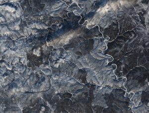
Images of Northeast Siberia recorded by Landsat 8. Image: NASA.
This peculiarity appears in all seasons of the year, although it is most evident in winter, when snow increases the contrast.
Explanations
Some experts have provided NASA with different explanations for this phenomenon. One hypothesis refers to the fact that this area of the Central Siberian Plateau lies within the Arctic Circle, therefore, 90 percent of the time is covered with permafrost, which sometimes thaws for short periods. It has been known that sections of soil that freeze, thaw, and re-freeze can form strange polygonal, circular, and striped patterns.
Elsewhere, however, these patterns tend to be smaller than those recorded in Siberia.
After the soil thaws and freezes again, it can form odd polygonal, circular, and striped patterns. Image: NASA.
Geomorphology researchers offer another explanation: In such colder regions, the earth can turn into “glysol”, which is permafrost soil at the top of two meters, where dark and light layers are usually distinguished based on the spread of organic or mineral matter and sediment content.
When the soil freezes and thaws, the layers divide and mix vertically. By repeating these cycles at intervals of time, the layers can line up and form striped patterns. Various types of tundra can grow on top of it, accentuating the streaks seen from space. However, this hypothesis has not been extensively tested.
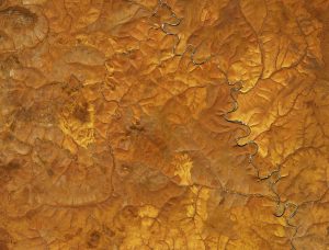
When the soil freezes and thaws, the layers split and mix vertically. Image: NASA.
Thomas Crawford, a researcher at the US Geological Survey, asserts that the lines reflect a pattern of sedimentary rocks known as “puff pastry geology,” as these rock layers have been exposed and dissected by erosion. When the ice melts or the rain drifts down a slope, chunks of rock break off and slide down into ravines. This erosion can cause interlocking patterns, seen as lightning bolts from space.
In winter, the flat parts are covered with snow, and they become lighter, while the darker areas correspond to the slopes. The fading of the striped pattern at the edges is due to sedimentary accumulation caused by erosion of millions of years.

Julian Barnes is an acclaimed British novelist, essayist, and short-story writer renowned for his elegant prose and intellectual depth. His work often explores themes of memory, history, love, and the complexities of human relationships. Widely regarded as one of the leading voices in contemporary British literature, Barnes has earned international recognition for his thoughtful and innovative storytelling.